Indian Springs | ||
 click for larger map |
| trail: | Logging road with gradual elevation of 400 feet |
| difficulty: | Moderately easy. |
| length: | 7 Miles round trip |
| elevation: | Trailhead is 1200 feet, climbs to 1645 and down to 1400 at Indian Springs |
| features: | The many remnants of the Casper, South Fork & Eastern Railroad trestle, built in the later part of the nineteenth century, are seen along most of the trail. |
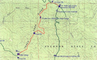
| directions: | Indian Springs is also close to the site of the Pomo's Three Chop Village where many relics were found by archeologists in 1984 and were determined to be from the ship, Frolic, wrecked off of Pt. Cabrillo in 1850. The Indian Springs campsite is a remote, hike-in-only campsite that provides a picnic table, outhouse and firepit. Take Highway 20 to milepost 17.3 ( Road 200 ), turn north onto 200 and follow for 5.5 miles, taking all left forks where there is an option, until you reach a four way intersection of roads 200 and 1000. ( # 1 on map) Park here and head west on 1000. Within 200 yards is a gate which should be open after April. Continue west until the next fork. ( # 2 on map ). Bear left on Road 330 which is marked with a wooden sign, followed by another gate. Walk around the gate and continue on road 330 for 3 1/2 miles or until you see a campsite on the right marked with a small sign, "Indian Springs." |
Trails Map

This page is sponsored by
Campaign to Restore Jackson State Redwood Forest
|
|
|||
| site designed and posted by the Caspar Institute this site generated with 100% recycled electrons! send website feedback to the MendoWalks webster | |||