Trestle Trail | ||
 click for larger map |
| trail: | Single track trail following the North Fork of the South Fork of the Noyo River. |
| difficulty: | Moderately difficult. Very hilly terrain from 400 to 1000 feet in elevation. Several creeks to jump or ford, depending upon the time of year. Lots of poison oak. |
| length: | 8. 4 miles round trip if doubled back. 6.2 miles one way if shuttle is set up. |
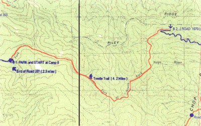
| features: | Beautiful remote trail that is not easy but well worth the effort. It can be approached from the east ( Road 361 ) or the west (Road 1070 ). Trail follows the North Fork of the South Fork of the Noyo River. An impressive waterfall is seen on the opposite side of the river halfway along the trail. |
| directions: | From Highway 20 turn north on Road 350, located at milepost 5.8. Follow 350 for 3 miles, cross the bridge just past the Fish Egg collecting Station. Follow Road 360 until you cross the next bridge, approximately 1 mile. This is the intersection of Roads 361, 360 and 363. Follow Road 361, on the right for 2.3 miles, until Campground 8 on the right. Park in the campground area and start the hike, 91 on the map. Follow this trail 4.2 miles, until Road 1070 is reached, #2 on the map. Turn around and retrace the trail to Campground 8 or the trail can be continued on 1070 to a parking area at the intersection of Roads 1000 and 200, approximately 2 miles. |
Trails Map

This page is sponsored by
Campaign to Restore Jackson State Redwood Forest
|
|
|||
| site designed and posted by the Caspar Institute this site generated with 100% recycled electrons! send website feedback to the MendoWalks webster | |||