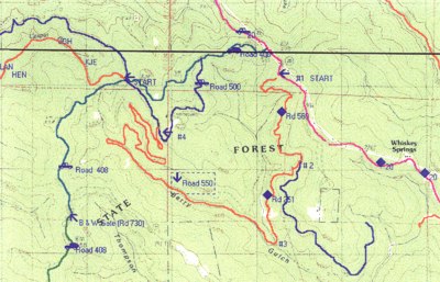
Berry Gulch | ||
 click for larger map |
| trail: | Part single track and part old logging road. Loop or shuttle. |
| difficulty: | Easy |
| length: | 6 miles |
| features: | Several miles of this trail are along the Berry Gulch Creek. Easy access to the creek for lunch/rest stop. |
| directions: | This is a beautiful, easy, six mile loop off of Highway 20 down to Berry Gulch and than back up to Road 408. At Highway 20's milepost 8.65, turn south on to road 560 which is marked on the yellow gate. There is plenty of parking here at the start (#1). Take this road down to the first main fork (#2). Take the right fork, which is Road 521 but unmarked, to the bottom of the gulch, until you reach the creek (#3). Turn right. From here to the next gate is road 550 and what a delight it is! You will hear the bubbling of the creek (even in the summer), notice many large second growth trees that help create a full canopy over the trail and a portion of the forest that has not been disturbed for many years. This is what a forest should look like. There is access to the creek for a rest/lunch spot about one mile after you reach the creek. After several miles along the creek, the trail to Road 408 climbs gently up the hill using long switchbacks. There's a spur going off the end of each switchback. So, beware of this if you want to stay on the main trail. After reaching the 550 gate (#4), turn right on to Road 500 which merges into 408. You can either walk back to where you parked on Highway 20 or have a car waiting for you at gate 550. If you wish to avoid walking on Highway 20, it's recommended that you use two cars. Park one at Gate 550 and one at Gate 560. |
Trails Map

This page is sponsored by
Campaign to Restore Jackson State Redwood Forest
|
|
|||
| site designed and posted by the Caspar Institute this site generated with 100% recycled electrons! send website feedback to the MendoWalks webster | |||