Chamberlain Creek Trail & Camellia Trail | ||
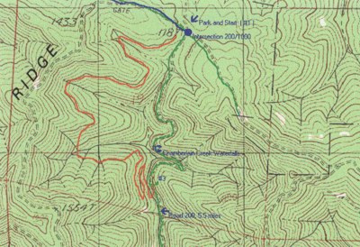
 click for larger map |
| trail: | Single track trail on fairly hilly, but easy terrain. |
| difficulty: | Moderately easy. Very gradual hills except last section of switchbacks on return to Road 200. |
| length: | Approximately 3 miles round trip |
| features: | Spectacular waterfall and small grove of old growth redwoods. |
| directions: | Take Highway 20 to milepost 17.3 and turn north on Road 200. Follow 200 for 5.5 miles, taking each left fork where there is an option. Park at the intersection of Roads 200 and 1000. ( #1 on the map ). On the southwest corner of this intersection is the beginning of Camellia Trail. This is a moderately easy single track trail that climbs up and down along the ridge above Chamberlain Falls. At the bottom of the canyon, a number of majestic,old growth redwoods still proudly stand around the creek. This is a marvelous spot to stop, look and admire these treasures of nature while refreshing yourself with food and water. Just to the west is the spectacular Chamberlain Creek Waterfalls (#2). Then follow the trail to the right of the falls that heads south and then goes into rather steep switch backs and wooden stairs that take you up to Road 200. ( #3 on the map). From the top of these stairs, it is only about 1/2 mile north back to your car. |
Trails Map

This page is sponsored by
Campaign to Restore Jackson State Redwood Forest
|
|
|||
| site designed and posted by the Caspar Institute this site generated with 100% recycled electrons! send website feedback to the MendoWalks webster | |||