Big River | ||
 click for larger map |
the Haul Road | Big River's tidal estuary connects to Mendocino Bay. Along its northern bank, the old railroad right-of-way, then for many years a busy logging haul road, provides, now that the trucks are gone, a flat, wide, scenic promenade into the heart of the forest. Dogs (leashed), bikes, joggers, and walkers all enjoy the walk along Big River. | |
Western End |
The trailhead is at the end of a dirt road reached by turning east (inland) off of Highway One just north of the Big River bridge. For a more serious walk, start in the village, cross the beach under the bridge, and continue along the shore until you come to the gate at the trailhead.
Few walkers and bikers follow this road for more than a few miles, although serious hikers can easily make their way along the remnants of the road, nearly overgrown, just over ten miles to the Mendocino Woodlands.
Along the road, several trails -- actually, old logging access roads -- head up the hill and lead into people's backyards or connect with Little Lake Road to the north. One ambitious two-car walk leads south from the CDF fire station (limited parking) approximately 3.5 miles inland along Little Lake Road and south along a ridge, connecting with the Haul Road about 3.3 miles from the parking area at Big River beach.
The first four miles of the river are tidal, and the road climbs and falls imperceptibly during that period. It climbs very gradually past the end of the estuary at Dry Dock Gulch. The maps on this page extend just to Dry Dock Gulch. | |
Big River |
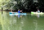
Being tidal, Big River's lower four miles also provide a wonderful boating experience. Private canoes, sailboats, kayaks, and rowboats can put in at the primitive boat ramp at the eastern edge of the sandy beach just below the trailhead. Rentals are available at Catch-a-Canoe on the south side of the river, reached by turning east on Comptche Ukiah road south of Big River bridge, and then, after a few hundred feet, turning north on the old Highway One and driving to the parking area where the old bridge used to be.
The wind is an environmental element to be reckoned into your boating plans. Typically, our prevailing northwest wind gets stronger as the day goes by, making the last reaches of the boaters' return difficult. Keep this in mind when deciding how far up-river to paddle. The tide is a much lesser influence, although the easiest rides will go up on the rising tide, and back dowen on the ebb.
Being tidal, the banks of the river are steep and muddy, but with care there are many little tributaries and shoals that provide good places to haul out and enjoy the river.
Wildlife on the river is much more abundant than along the road. Osprey, Great Blues and several other species of herons, and innumerable wild and feral ducks use this as their primary feeding and resting area. Watch especially for river otters. | |
 click for larger map |
|
This page is sponsored by the Caspar Community "Improving the quality of all life in Caspar" |
|||
| site designed and posted by the Caspar Institute this site generated with 100% recycled electrons! send website feedback to the MendoWalks webster | |||